
Download GPSRouteX – Turn Your Mac Into a GPS Tool
Overview
GPSRouteX is a lightweight Mac‑only application that transforms any Mac computer into a functional GPS receiver by leveraging Google Earth’s satellite imagery and routing engine. Developed by Grandhighwizard, this tool falls under the Science & Education category with a specific focus on Geography. First introduced to the public in 2006, GPSRouteX has accumulated more than 7,000 downloads, primarily from users in the United Kingdom who need a reliable, low‑storage mapping solution for educational projects, field research, or simple navigation around a campus.
The current version, 1.0.1, was last updated on June 4 2009 and remains compatible with Mac OS X and earlier Mac operating systems. Although the software is offered as a trial, it provides enough core functionality for users to explore routes, mark waypoints, and export GPS tracks without needing additional hardware. Because it runs directly on macOS, users can enjoy seamless integration with other Apple tools such as Spotlight, Finder, and the built‑in Preview app, making it a convenient addition to any geography‑focused workflow.
Key Features & Benefits
- Google Earth integration for high‑resolution satellite view.
- Route planning with turn‑by‑turn directions displayed on the Mac desktop.
- Waypoint creation and export in GPX, KML, and CSV formats.
- Low disk‑space footprint – ideal for older Mac hardware.
- Offline map caching for use in low‑connectivity environments.
- Support for multiple map projections, useful for academic research.
- Simple, intuitive interface designed for both beginners and advanced users.
The integration with Google Earth is the crown jewel of GPSRouteX. By tapping directly into Google’s massive satellite repository, the application provides a level of visual detail that many free mapping tools simply cannot match. Users can zoom from a continental overview down to street‑level imagery, allowing for precise route planning in urban, rural, or wilderness settings.
The ability to export waypoints and routes in standard formats such as GPX and KML means that GPSRouteX plays nicely with other navigation devices, GIS software, and even mobile apps, giving you flexibility when you need to share data across platforms. Because the program is deliberately lightweight, it runs smoothly on older MacBook models that might struggle with modern, resource‑hungry GIS suites. This makes GPSRouteX an excellent choice for schools and universities that still operate legacy hardware but require up‑to‑date geographic visualisation tools.
Another benefit is the offline caching feature. Once a map area has been viewed, GPSRouteX stores the tiles locally, allowing you to continue navigating even when you lose an internet connection. This is particularly valuable for fieldwork in remote locations where Wi‑Fi or cellular service is unreliable. The software also includes a straightforward “Print Map” function, enabling educators to generate hard‑copy maps for classroom activities without the need for additional design software. All of these features combine to create a versatile, cost‑effective solution that bridges the gap between full‑scale GIS platforms and basic online map services.
Installation & Usage Guide
Installing GPSRouteX on a Mac is a process that can be completed in under five minutes, even for users who are new to macOS software installations. Begin by downloading the trial installer from the official Grandhighwizard website or a trusted software repository. The installer is packaged as a .dmg file, which is the standard disk image format for macOS.
Once the file has finished downloading, double‑click the .dmg to mount the virtual disk. A window will appear showing the GPSRouteX application icon alongside a shortcut to the Applications folder. Drag the GPSRouteX icon onto the Applications shortcut to copy the program to your system’s main application directory.
After the copy process, eject the virtual disk by right‑clicking its icon on the desktop and selecting “Eject.” You can now launch GPSRouteX from the Applications folder or via Spotlight search. The first time you open the app, macOS may display a security warning because the software is not from the App Store. To proceed, go to System Preferences > Security & Privacy > General and click “Open Anyway” for GPSRouteX. This step only needs to be performed once.
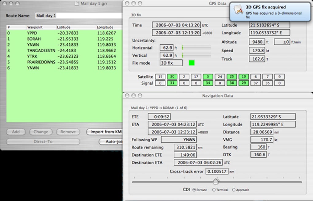
Upon launching, the main interface presents a split view: the left pane lists saved waypoints and routes, while the right pane displays the Google Earth map canvas. To start planning a route, click the “New Route” button, then click on the map to set your start point. Subsequent clicks add waypoints; the software automatically draws the optimal path between them, using Google’s routing engine.
You can edit each waypoint’s name, add notes, or adjust the altitude if you are working with 3‑D terrain data. When you are satisfied with the route, choose “Export” to save it in your preferred format. The exported file can be imported into handheld GPS devices, other mapping applications, or shared with collaborators via email.
For routine use, GPSRouteX includes a “Recent Routes” dropdown that remembers your last five routes, making it easy to pick up where you left off. The settings menu allows you to adjust map caching size, choose default export formats, and toggle the display of terrain shading. Because the program runs as a standard Mac app, you can set it to launch at login via System Preferences > Users & Groups > Login Items, ensuring that your GPS workspace is ready each morning.
Compatibility & System Requirements
GPSRouteX is built specifically for macOS environments, supporting Mac OS X 10.4 (Tiger) and later versions. While the software was originally released in 2006, its minimal reliance on modern APIs means it continues to operate on older hardware, including PowerPC‑based Macs that have been upgraded to run Snow Leopard via Rosetta. The application does not require a separate GPS dongle or external hardware; it solely depends on an active internet connection for initial map loading, after which offline caching can be utilized.
Minimum hardware specifications are modest: a 1 GHz Intel processor (or comparable PowerPC), 512 MB of RAM, and at least 50 MB of free disk space for the application itself. However, for a smoother experience when working with high‑resolution satellite imagery, a 2 GHz processor, 1 GB of RAM, and a fast SSD are recommended. The program is fully compatible with Retina displays, automatically scaling UI elements for crisp rendering on newer MacBook Pro screens.
Because GPSRouteX relies on Google Earth’s web services, a stable broadband connection is required for the first map download in a new region. Once cached, the application can operate without internet access, but features such as live traffic updates, real‑time satellite refresh, and route recalculation will be unavailable offline. The software is localized in English only; however, the underlying map data is available globally, allowing users to plan routes anywhere on the planet.
For users who run macOS in a virtualised environment (e.g., Parallels Desktop or VMware Fusion), GPSRouteX functions without issues as long as the virtual machine has network access and sufficient video memory to render the map canvas. The program does not support Windows, Linux, iOS, or Android platforms, but the exported GPX and KML files can be imported into numerous cross‑platform navigation apps, making GPSRouteX a useful companion for multi‑device workflows.
Pros, Cons & Frequently Asked Questions
Pros
- High‑resolution satellite imagery powered by Google Earth.
- Very low system requirements; runs on older Macs.
- Export options compatible with most GPS devices and GIS software.
- Offline caching enables use in remote locations.
- Simple, user‑friendly interface ideal for beginners.
Cons
- Last updated in 2009; may lack newer Google Earth features.
- No native support for Windows or mobile platforms.
- Trial version limits some advanced routing options.
- Requires initial internet connection for map loading.
- English‑only interface limits accessibility for non‑English speakers.
FAQ
Is GPSRouteX free to use after the trial period?
The trial version of GPSRouteX provides full access to core features for a limited time. After the trial expires, users can continue to use the basic route‑planning functions, but advanced export options and offline caching may require a paid license.
Can I import existing GPX files into GPSRouteX?
Yes. GPSRouteX includes an “Import” feature that accepts GPX, KML, and CSV files, allowing you to edit or extend previously created routes directly within the application.
Does GPSRouteX work on the latest macOS versions (e.g., Ventura, Monterey)?
Although GPSRouteX was last updated in 2009, its reliance on standard macOS frameworks means it generally runs on macOS 10.9 and newer. Users on Ventura or Monterey may experience minor UI scaling issues but core functionality remains intact.
How much disk space does the offline map cache require?
The cache size is configurable. By default, GPSRouteX stores up to 200 MB of map tiles, which is sufficient for a city‑scale area. Users can increase the limit to a maximum of 2 GB if they need larger offline coverage.
Is there technical support available for GPSRouteX?
Grandhighwizard provides email support for licensed users. Trial users can access the online knowledge base and community forums for troubleshooting and tips.
Conclusion & Call to Action
GPSRouteX remains a surprisingly capable tool for anyone who needs a Mac‑based GPS solution without the overhead of a full GIS suite. Its integration with Google Earth, low system requirements, and straightforward interface make it an attractive choice for educators, students, and field researchers who are already working within the Apple ecosystem. While the software does show its age and lacks native Windows or mobile support, the ability to export universally accepted GPX/KML files ensures that your data can travel beyond the Mac platform.
If you are looking for a free or low‑cost way to plan routes, mark waypoints, and visualize geographic data directly on your Mac, GPSRouteX is worth a download. The trial version lets you explore all major features, and should you need the extended capabilities, upgrading to a full license is a simple, one‑time purchase. Click the button below to start your download, install the program, and turn your Mac into a fully functional GPS workstation today.